


San Marcos has moved its GIS Environment to the Cloud! The City has reduced on-site infrastructure costs and can utilize cloud infrastructure’s performance, security, and integration capabilities. San Diego-based Esri business partner Quartic worked hand-in-hand with City staff to assess organizational needs and designed and built an Esri ArcGIS Enterprise Cloud environment running in Microsoft Azure. The City’s primary goal, to relieve the strain on overburdened on-site resources, was achieved and exceeded, with a robust environment that will improve communication between people and multiple specialized municipal systems.
Modernized Infrastructure
The City’s GIS staff is responsible for maintaining and providing high-quality, site-specific, authoritative spatial data to all departments within the City, including Planning, Development Services, City Clerk, Finance, Fire, Public Works, Parks and recreation, Storm Water, and Community Economic Development. Since 2006, the City has developed over a hundred different GIS data layers and maps that have supported both planning and operations needed for development services and other departmental business.
The City has been running its GIS hardware and software in an on-premise environment for over a decade. As more GIS functionality has moved to the cloud, it has become common for cities to move away from limited internal infrastructure to more flexible and reliable off-premise solutions. The City’s miniature GIS web deployment has gone from a poorly performing, low-reliability mapping system to one that is stable and ready for the future.
Modernized Database
The GIS database underwent a significant overhaul in the cloud migration project. The GIS database structures were streamlined, eliminating redundancies and enabling better data management. The database version is now 10.9.1.
From ArcMap to ArcGIS Pro
The City also took advantage of this opportunity to retire its old GIS desktop client software, ArcMap. Migration is proving to be a success, and Esri’s ArcGIS Pro is proving to be a big jump in functionality and adaptability. ArcGIS Pro, the powerful single desktop GIS application, is a feature-packed software developed with enhancements and ideas from the ArcGIS Pro user community.
Smooth Deployment
Quartic worked closely with the City’s CIO to develop a comprehensive design and implementation strategy for this cloud implementation and upgrade project. The production rollout of the new system needed to go smoothly and without hiccups because there were existing system integrations supporting mission-critical applications. City crews use Lucity daily, the city’s asset and work order management system. The City wanted a precise and automated rollout of the new system, so Quartic strategically automated the deployment process using a streamlined scripted solution.
The team considered two rollout script development paths: Esri’s ArcGIS Enterprise Cloud Builder Tools or Microsoft’s Azure Bicep. Both solutions would have been successful, but since the City’s Information Technology staff have expertise with Azure DevOps Pipelines, the final decision was to use Azure Bicep. With the City leading, the comprehensive rollout plan enabled Quartic to execute the scripts, resulting in a smooth deployment into production. The migration went seamlessly, with no data or configuration loss and no service failure to the users.
The Architecture
The architecture of the new solution required careful consideration to ensure that the foundation was set for the future needs of GIS applications. The team carefully planned all components, including the network, storage, database, applications, and security. This careful planning has set a strong foundation for growth. While upgrading the software versions, migrating the third-party applications, and completing the ArcGIS Enterprise deployment, focus was placed on the new environment’s stability, performance, and reliability.
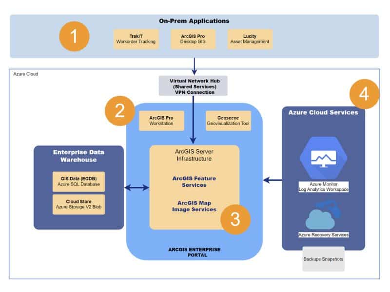
Network: Azure Cloud is connected to the City’s local network, and there is a solution for resolving website names between Azure and the on-site network. The cloud networks consist of a central network for shared cloud services and another specifically for ArcGIS Enterprise.
Storage: Azure’s newest storage system replaces the City’s aging on-premise file storage. All components leverage premium storage options and Azure and Esri tools to ensure data is safely backed up to multiple locations.
Database: Azure’s managed database stores the City’s GIS data, which can scale to fit their needs and is also cost-efficient. This component was configured to create data backups every 12 hours to protect the data.
Application and Web: A “multi-machine” ArcGIS Enterprise deployment model runs on the latest Azure editions of Windows and Linux. This model best fits the City’s desire for future growth. Automatic operating system updates are tailored to ensure that all GIS applications are consistently available and responsive.
Security: To enhance security for the end product, the team used cloud-native security tools in Windows and Azure that continually monitor for potential threats following Microsoft’s security recommendations.
Azure Cloud Architecture Diagram
Used Technology
The new infrastructure was built using Azure Bicep Templates and Azure Pipelines (DevOps). Esri PowerShell DSC was used to automate the installation and configuration of ArcGIS Enterprise. The team used Azure Monitor, Recovery Services, and Automation Update Manager for regular infrastructure maintenance, backups, and upkeep.
- Azure Blob Storage for Cloud Store of reference imagery services. Fileshare for document storage.
- Azure SQL is a managed database for scalability and low maintenance.
- Azure Application Gateway V2 to scale and accommodate visitors from the public internet.

Esri Technology
- ArcGIS Enterprise (Server, Datastore, Portal)
- ArcGIS Pro
- ArcGIS Online
- PowerShell DSC for ArcGIS Enterprise
- ArcGIS Notebook Server advanced
Reduced Risk
Having GIS in the cloud will reduce the reliability risk and costs of maintaining on-site infrastructure. By retiring two on-premises servers and instead leveraging the latest technology, the City will experience a faster and more stable environment, enabling City staff to do their jobs more efficiently.
The new deployment also ensures that there will be no recurring outages that waste valuable time and resources. The speed at which staff can access and edit GIS data is increased. The display speed of imagery has also significantly improved, making spatial data editing more straightforward and efficient. Staff can now take advantage of the performance, security, and integration capabilities provided by Cloud infrastructure.
Future Collaboration
The City and Quartic’s implementation team worked together to tackle technical and logistical challenges. The result was an Azure-hosted complete deployment of ArcGIS Enterprise, replacing an on-premises ArcGIS Server and Enterprise geodatabase. The team also implemented an editing and publishing workflow leveraging ArcGIS Pro.
Both parties were pleased with the project outcome and look forward to continuing the collaboration in 2024. Discussions are ongoing regarding further improvements for the GIS program, such as leveraging Esri’s ArcGIS Monitor application for better performance monitoring and migrating data editing to hosted data store items.
“Apart from already leveraging one of their staff as “on-site” staff for the City, I’m myself a former member of their staff and was familiar with their excellent team and leadership. I was 100% confident in their ability to deliver a fully functional, secure, and integrated Azure cloud migration product.“ – GIS Program Manager