Esri's business partner, Quartic Solutions, worked with the City to assess organizational needs and designed and built an Esri ArcGIS Enterprise Cloud environment running in Microsoft Azure.
In September 2015, the City began migrating to the Accela Civic Platform, and the Accela ROW Management Module was selected as the replacement for IMCAT.
Improving bus stops will make public transportation safer and more enjoyable. In early 2022, a transit company was looking for solutions to maintain the condition of bus stops and bus stop amenities.
The City of San Marcos wanted to have a way to share mapping data easily and directly with citizens. They developed an easy-to-use website that is now open to the public.
GIS can be used in many ways to improve the operations of cities and local governments. The City of El Cajon uses GIS as a tool to discover, maintain, and visualize its NFPA 704 Warning...
From highly-technical solutions to complex problems to fast response and general staff augmentation. Quartic provides expertise to support El Cajon’s GIS needs as they occur.
GIS technology can be used in various industries to enhance efficient data usage and, through that, better decision-making. Long Beach Transit (LBT) has realized the importance of good-quality data.
Improving the accuracy of the LA Homeless Count by utilizing the latest location-based technology. The application developed was based on Esri ArcGIS® QuickCapture.
SanGIS, a Joint Powers Authority (JPA), improved processes for maintaining the regional GIS by implementing Esri’s Parcel Fabric and ArcGIS Pro editing tools.
The City of San Diego has recently expanded its green waste recycling program to include weekly organic waste recycling collection for all households currently eligible for collection services.
We're pleased to be recognized by Esri as a State and Local Government Specialty Partner. Partners in the newly launched State and Local Government Specialty Program.
Esri offers specialty badges for partners who meet the qualifications for each specialty. Quartic can now proudly introduce itself as an Esri ArcGIS System Ready Specialty badge owner.
Quartic worked with a client who identified ideal event locations based on a customer's specific event needs and then coordinated with local jurisdictions to obtain any required permits.
Cupertino significantly improved the daily processes for its mobile workforce and streamlined the integration of its GIS and EAM in the field by migrating to the geospatial cloud.
The County of San Diego recently upgraded to a full ArcGIS Enterprise environment, and the number of users accessing the Portal has increased. Users are creating maps, applications, and dashboards.
GIS is a crucial unifying technology for the City of San Diego as it works to support and sustain its 1.4 million citizens. GIS is a crucial unifying technology that supports and sustains its 1.4...
Pursuing open data, transparency, and collaboration in the GIS world is a rather large undertaking technology-wise. If you don’t get ahead, the risk of falling behind is too great.
We're one of four partners to make the list in the Fall 2019 issue of ArcNews' Esri Partner Solution Stories. These stories illustrate our capabilities as Esri Partners in helping users get the most out of their...
Quartic staff attended a training course covering ArcGIS Solutions for Emergency Management. The solution was developed from the expertise and experience of the Esri Disaster Response Program.
San Diego's Transportation and Stormwater Department manages the policies and procedures to minimize damage to public infrastructure and recover costs from ROW.
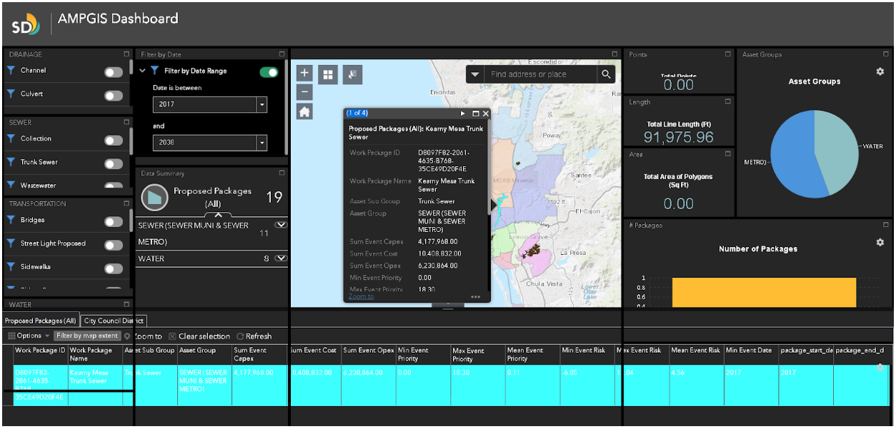
Implementing Asset Management In 2018, the City of San Diego rolled out Phase 1 of a SAP-based software solution to improve the City’s management of infrastructure assets. The IAM San Diego Project, a citywide strategic...
Using applications available through ArcGIS Online, such as Web AppBuilder and Operations dashboard, combined with field applications (Survey123, Collector, and Workforce),
Using SAP HANA along with Esri ArcGIS, the City of San Diego was able to leverage state-of-the-art technologies to put location information into the hands of the Street Sweeping Supervisors.
Ready for Action?
Mapping and spatial analysis provide insight to a great variety of industries and markets. Quartic will empower your business by harnessing the intelligence of spatial technology.